
Document
Horsham District Nature Recovery Network report
Last updated: August 2021
Introduction
Nature is in dramatic decline, both nationally and within the Horsham District. To reverse this decline better and more connected habitats are needed; which can be achieved by establishing a Nature Recovery Network (NRN).
This document sets out how a NRN could potentially be developed for Horsham District, taking advantage of the existing areas with biodiversity value or high biodiversity potential, and considering how they could be improved and linked together. Developing an NRN underpins the Wilder Horsham District project, which is a partnership between the Sussex Wildlife Trust and Horsham District Council.
The Network will incorporate rural and urban areas, to ensure that wildlife is not confined to isolated protected sites and can move through the landscape. Built up areas, and infrastructure such as roads, create a challenge for an NRN but wildlife corridors can be built around and even through settlements. Corridors also minimise the habitat gaps to be crossed and, in some cases, can even close them completely, for example crossing a road via a green bridge or underpass.
The Horsham NRN map work is aspirational, demonstrating what could be achieved and where action could be targeted to reverse the biodiversity crisis. However, the Network and Nature Recovery are reliant on the good-will and expertise of land-owners and land-managers for delivery.
The goal of the Wilder Horsham District project is to work with land-managers and communities at all levels right across the district to help integrate nature recovery and connectivity into the many different land-uses. This document is not intended to dictate how any land-manager should manage their land but rather to highlight those areas that have particular features that give them high nature potential.
The map is based on ecological data and principles and on the latest best practice and guidance, including that from Natural England. It may be updated to reflect further national guidance. The map is still in development and will be improved and refined as more data is added; although the core of the NRN, such as the location of watercourses, will not change.
Undoubtedly there are areas that are rich in wildlife or have potential for nature recovery that do not appear on this first version of the map. The document should be considered with this in mind.
Nature Recovery Networks
The idea of establishing NRNs was a significant commitment in the Government’s 25 Year Environment Plan as a way to reverse the dramatic decline in wildlife that has occurred over the last 50 years. They are based on the Lawton principles of: Bigger, Better, More and Joined Up. The Government’s Environment Bill is expected to introduce a statutory requirement to prepare local nature recovery strategies, including NRNs, and effective measures at policy level will also be important for enabling nature recovery.
The Wilder Horsham District Project has been established in response to the urgent pressures on biodiversity with the aim of accelerating the delivery of measures for nature recovery. Consequently, this first version of a map of a Horsham District NRN identifies where buffers could be added to existing sites (bigger), areas which can be improved (better), areas with high potential for nature recovery (more) and where there could be corridors or stepping stones between sites (joined up).
Part of the aim of the NRN is the restoration of natural processes (Natural Processes are the interactions that shape our planet and support life), in particular:
- Natural Flood Management (NFM): when natural processes are used to reduce the risk of flooding and coastal erosion. Examples include: restoring bends in rivers and changing the way land is managed so soil can absorb more water.
- Natural Grazing: Grazing methods that mimic the natural grazing behaviour of wild herds. This can increase grass productivity by up to 300% and significantly improve soil quality.
- Ecological Succession: the gradual process by which ecosystems change and develop over time. Nothing remains the same and habitats are constantly changing.
This will bring benefits not only for wildlife but also for the communities of The District, such as reduced flood risk and clean water. The NRN can also make a significant contribution to tackling climate change by increasing carbon storage. It will also bring health and wellbeing benefits by enabling people to increasingly enjoy and connect with nature where they live, work and play.
The map contained in this document is at the District scale, but the principles can be applied at different levels, from the entire country down to a single town or village. In towns and villages, for example, open spaces, woodlands and water courses could also be managed to help wildlife thrive and bring nature closer to people. NRN maps at Parish scale will help communities to take action that will contribute to the District wide NRN. In its turn, the NRN for the District will need to be part of a wider Network across the whole of Sussex and the South East. The current map is still evolving, for example, it does not include species information (e.g. specific areas that have been identified for key local species that are vulnerable to local extinction, or areas to bolster populations of species that thrive in the District but are vulnerable elsewhere). It also focuses specifically on biodiversity, as the primary driver for this work is to reverse losses in wildlife. It does not incorporate information on other aspects of interest or concern such as accessibility to nature [these should be addressed in other strategies and programmes such as a Green Infrastructure strategy].
The role of Wilder Horsham District
The main objective of the Wilder Horsham District project is to initiate the development and delivery of the local NRN. The project brings together the Sussex Wildlife Trust and Horsham District Council. The two organisations have distinct roles in the project, which are outlined in this paper. However, these organisations will not be able to deliver the Network alone and partnership working will be vital. There are two Project Officers, the Landowner Advisor and Community Support Officer. Together, they will work with landowners, farmers, communities, Parish Councils and other organisations to promote Nature Recovery and improve landscape connectivity for the benefit of wildlife.
The role of the Sussex Wildlife Trust
The Sussex Wildlife Trust employs the two project officers and supports them via the project team and steering group. Sussex Wildlife Trust also provides technical and expert support for the project.
As a conservation organisation focused on protecting and enhancing the rich natural life of Sussex its focus is on using Nature Recovery Networks to drive Nature’s Recovery across all of Sussex. As such Sussex Wildlife Trust asserts its role in encouraging the District Council to make evidence based decisions using the Nature Recovery Network information that the Wilder Horsham District Project has produced and will continue to refine. The Sussex Wildlife Trust will promote Nature’s Recovery in relation to the Council’s other roles and responsibilities, asserting the importance of the network for the ongoing ecological integrity of the district, particularly where the Council’s other duties might result in a competing priorities.
The role of Horsham District Council
The District Council supports the project officers based at the Sussex Wildlife Trust via the project team and steering group. There is close working between both organisations, for example, encouraging and supporting volunteers to undertake work that assists in the development of the network.
The District Council already manages many of its parks and countryside sites for the benefit of wildlife. However, it will review its land management practices so that it contributes to the developing NRN. Both organisations will work to inspire communities throughout the area to value wildlife and take action, on land of all sizes, to help it thrive. This will be an essential part of delivering the NRN.
The District Council is also responsible for land use planning in the District (excluding the South Downs National Park). The Government guidance on how Nature Recovery Networks should interact with development is set out in the National Planning Policy Framework; the details of this are included at the end of this document (see Appendix 1). In summary, planning should take account of the NRN and use it to inform where development can be made sustainable by protecting and enhancing nature. Adverse impacts should be avoided and opportunities to incorporate improvements for wildlife in and around development should be encouraged. The upcoming mandatory requirement, in the Environment Bill, for Biodiversity Net Gain reinforces that there must be wildlife gains as part of development. The NRN map will help to identify the types of Biodiversity Net Gains that could be secured.
Construction of the Nature Recovery Network
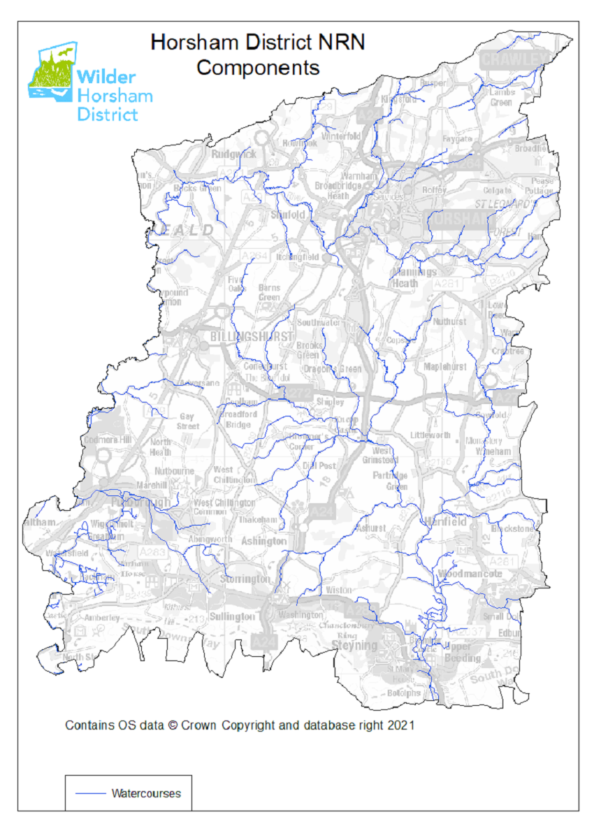
The basis of the network: water bodies
Water bodies, especially rivers, are extremely important in an NRN. The restoration of Natural Flood Management is vital for holding water in the landscape both for improving habitat quality and for preventing flooding of settlements. The District has the advantage of having two major river systems that cover most of the area. The Adur and its tributaries form a network that covers the central and South Eastern parts of the District. Tributaries of the Arun flow through the north of the district and the main river runs down the western boundary. In connectivity terms, rivers are natural corridors, as well as being valuable habitats in their own right, and so can form the basis of a NRN.
The importance of water
Wet habitats, especially wet woodlands, are some of the most biodiverse habitats in the UK and the drying up of the landscape has been a significant factor in the recent biodiversity loss, especially in declines of invertebrates. Habitat restoration along watercourses has huge potential for driving species recovery.
Water quality is also extremely important for both people and wildlife and vegetated buffer zones along watercourses are effective in removing pollutants from surface run-off.
Returning sections of our waterways to a more natural state would slow down the flow and create a more balanced system of water circulation.
In particular the proposed licenced reintroduction of beaver to the District would restore a keystone species that would have far-reaching ecological benefits.
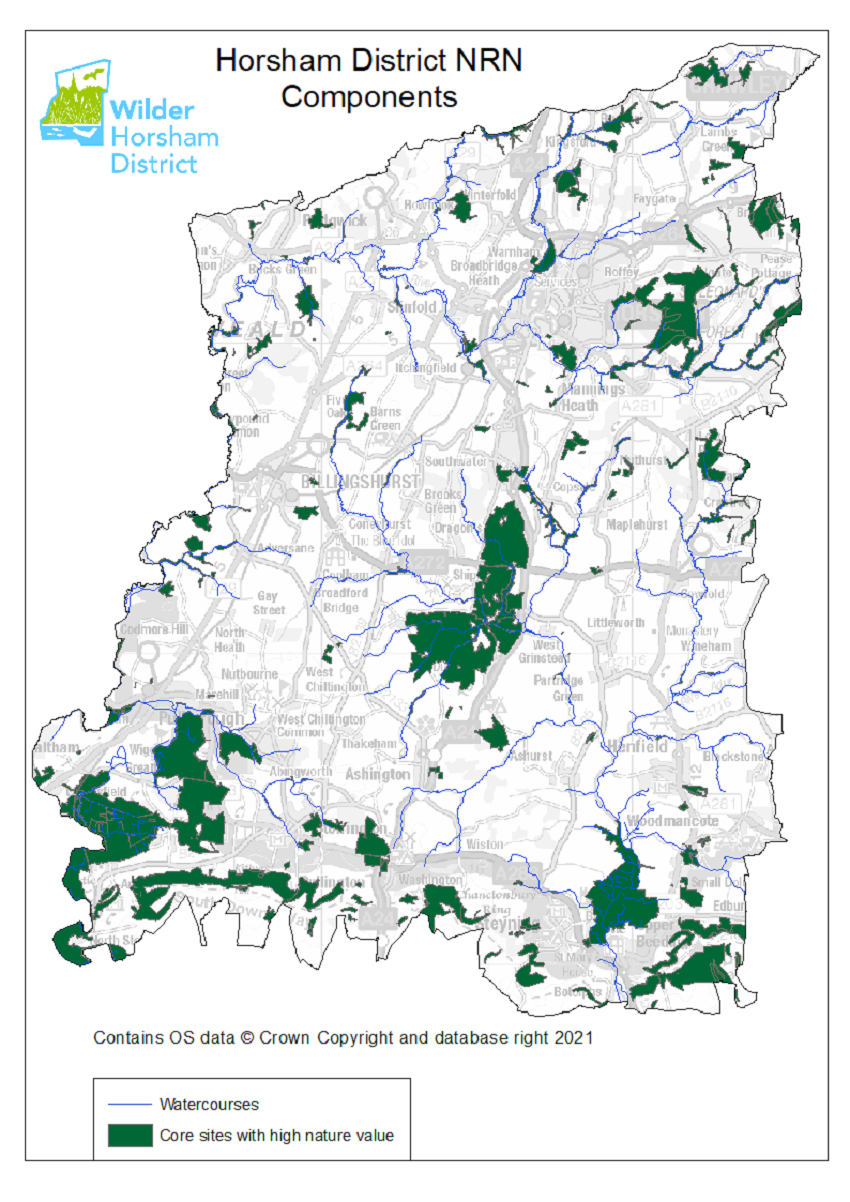
Core sites (better)
These sites are the core of the network. They are already existing sites that have already been identified as being crucial to wildlife in the district because of either their intrinsic quality, that they are managed with wildlife and nature as the key drivers or both. The Network should aim to improve the quality of these sites, many of which already have statutory obligations for management or protection through local provisions.
These include the Sites of Special Scientific Interest (SSSI), Local Wildlife Sites (LWS), Nature Reserves (SWT, NT and RSPB) and sites managed by Forestry England. Also included are the Natural Capital Assets in the district; these are habitats of particular value in terms of biodiversity and ecosystem services. The habitats concerned are: Floodplain Woodland, Lowland Fen, Reedbed, Lowland Heath, Acid Grassland, Intertidal Mudflat, Lowland Meadow and Lowland Calcareous Grassland.
Figure 2. Core sites in Horsham District
The rewilding project at Knepp is also included in these core sites. This site is important for two reasons. As a rewilding project it has shown what can be achieved for Nature Recovery. Additionally, in terms of the NRN it occupies a strategic position almost exactly in the centre of the district. It is therefore ideally placed to serve as a hub for the Nature Recovery Network.
References for the core sites
- SPA: Land notified under the Wildlife & Countryside Act 1981 (as amended) and the Conservation (Natural Habitats, & c.) Regulations 2010 (as amended);
- SAC: Land notified under the Conservation of Habitats and Species Regulations 2017 (as amended); Ramsar sites: Wetlands of international importance designated under the Ramsar Convention;
- SSSI: Land notified under the Wildlife and Countryside Act 1981 (as amended). Site Search (naturalengland.org.uk)
- LWS: Non-statutory sites that contain features of substantive nature conservation value. Administered by the Sussex Local Wildlife Site Initiative
- Natural Capital Assets: Sussex Local Nature Partnership
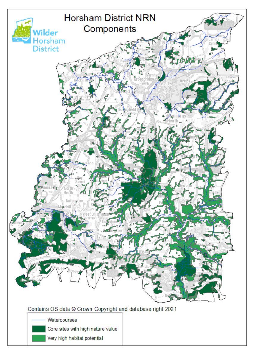
New sites (more)
There are areas within the district that have been identified as having very high potential for Nature Recovery. The location of these sites is fixed by their geography and/or underlying geology. The main areas are those where heathland or acid grassland restoration is possible (mainly on the greensand), where lowland calcareous grassland restoration is possible (on the chalk of the South Downs) or where restoration of wet habitats are possible (mainly along the river valleys and tributaries of the Adur and the Arun).
Figure 3. Sites with Very High habitat potential in Horsham District
These sites are high priority to target with management advice because of the significant contribution they could make to Nature Recovery but also because of the connectivity they provide between other sites. Ideally as much of this area as possible would become part of the core of the Nature Recovery Network with management to benefit nature.
References for very high habitat potential Sites
Tink, M. and Baker, R. (Jan 2012) Adur & Ouse Catchment Habitat Potential Model, A Sussex Biodiversity Record Centre report supported by Sussex Wildlife Trust and funded by the Environment Agency
Tink, M., Baker, R. and Southgate, F. (July 2011) Arun & Rother Catchment Habitat Potential Model, A Sussex Biodiversity Record Centre report funded by Natural England and the South Downs National Park Authority.
Tink, M. and Baker, R. (Nov 2011) South Downs Wooded Heath Habitat Potential Model, A Sussex Biodiversity Record Centre report funded by the South Downs Heathland Partnership.
Tink, M. and Baker, R. (June 2012) South Downs National Park Lowland Calcareous Grassland Habitat Potential Model, A Sussex Biodiversity Record Centre (SxBRC) report funded by the South Downs National Park Authority.
Other new sites and buffered sites (more and bigger)
Another targeted landscape-scale approach to conserving biodiversity and the basis for an ecological network are the Biodiversity Opportunity Areas (BOAs). Each area has a set of conservation priorities for biodiversity so that habitat enhancement, restoration and recreation projects can make the most of opportunities to establish large areas of habitat and connections between them. They are included in the map below (Figure 4.)
Biodiversity Opportunity Areas (BOAs)
The Biodiversity Opportunity Areas (BOAs) are priority areas of opportunity for restoration and creation of Biodiversity Action Plan (BAP) habitats.
They are a spatial representation of the BAP targets and the BOAs are areas of opportunity, not constraint. The BOAs included in the map do not include all the BAP habitat in the region, nor do they include all the areas where BAP habitat could exist. In particular, more work is needed to develop approaches in urban and in marine environments.
The Biodiversity Opportunity Areas Map is the property of the members of the South East England Biodiversity Forum © South East England Biodiversity Forum 2009. Reproduction of the BOA Map is subject to conditions © Crown Copyright. All rights reserved 2021.
Figure 4. Other sites with high restoration potential and buffering of core sites.
There are twelve BOAs that are wholly or partly within the District, these are: Adur to Newtimber; Woods Mill Steam to Adur; North Bramber Floodplain; Central Downs Arun to Adur; Lower Adur Arun Watershed; Knepp Estate with Fluvial extensions; The Mens and Associated Barbastelle Flightlines; Parham to Fittleworth; Ifield Brook; The St. Leonard’s Watershed; Rusper Ridge and Houghton to Coldwaltham.
Also included here are the two designated landscapes that overlap with the District. These are the South Downs National Park (SDNP), in the South of the District, and the High Weald Area of Outstanding Natural Beauty (HWAONB). These areas are not selected solely on the basis of biodiversity, but both have biodiversity interest and potential for habitat improvement or restoration, particularly where linking sites is concerned. Additionally some known sites where wilding or regenerative agriculture is planned have been included here.
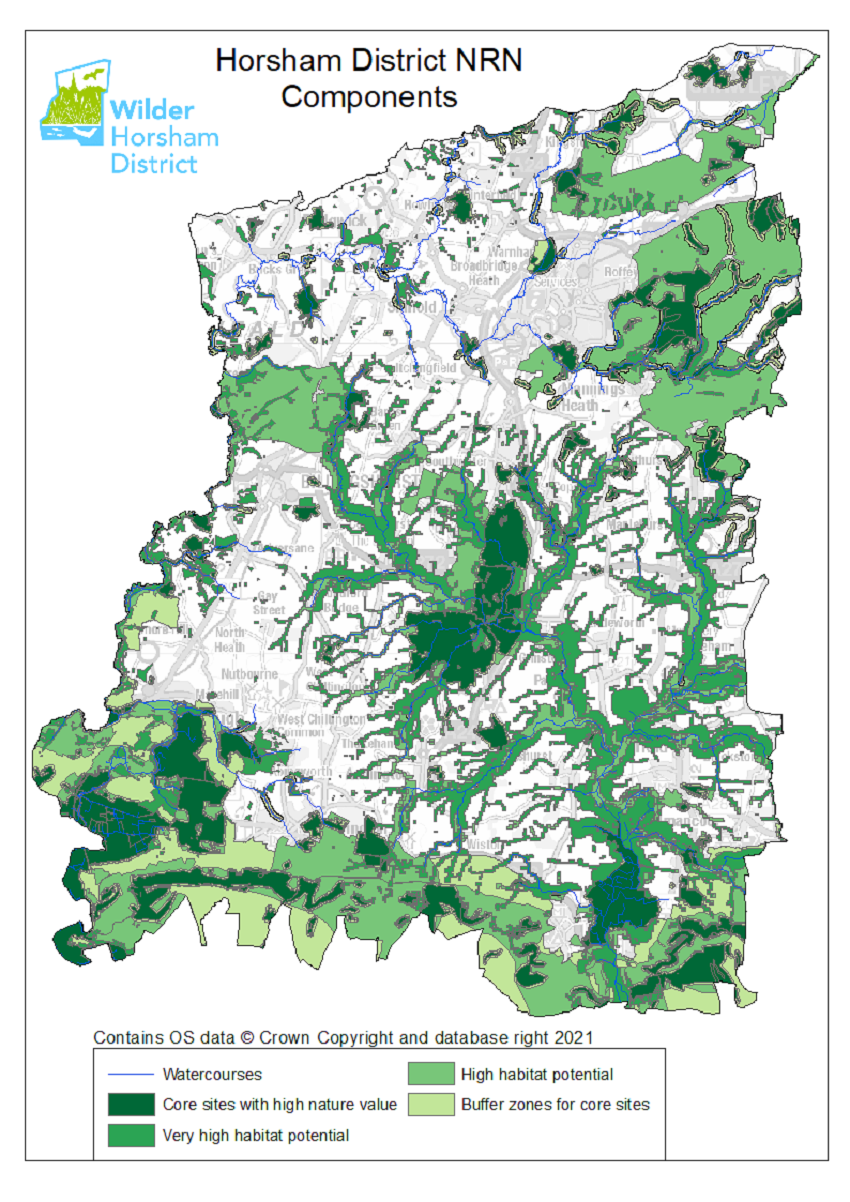
Existing or proposed core sites could be made bigger with buffering, in other words by providing a transition habitat that protects the main habitat. Buffers vary in size and composition depending on the size and type of area they are protecting. Any size of buffer is generally an improvement but, of course the bigger the better. Quite a lot of work has been done on the size of buffers for different habitats. Twenty metres has often been used as a “rule of thumb” buffer width with thirty metres for more sensitive sites such as ancient woodlands. However, it can vary by site and a number of methodologies have been devised to calculate buffer sizes (e.g. Sussex Wildlife Trust's Landscape Buffer Strips brochure). Typically wet features need the biggest buffers and if all large water courses in the district could have a 30m buffer with 12m buffer for the smaller water courses then that would be hugely beneficial. Buffers that are intended to provide wildlife habitat and woody debris or maintain water temperatures need to be at least 30m. Some of the potentially very highly biodiverse wet habitats such as riparian woodland benefit from a much wider buffer to hold the moisture and maintain habitat quality. Research suggests that some species groups, such as birds, may require wider buffers of up to 144m. Obviously, buffers will be very site specific and will need to take into account current land uses but the NRN should aim for a high standard supported by ecological principles. The standing advice from NE for ancient woodland states “a minimum buffer of 15 metres” with the caveat that “larger buffers may be required” (Ancient woodland, ancient trees and veteran trees: protecting them from development - GOV.UK). However the NRN is based on ecological evidence rather than planning requirements.
Corridors and stepping stones (joined up)
The core sites combined with what might be termed the ‘fixed’ areas for improvement provide a very solid foundation for a Nature Recovery Network. However there are still gaps and this is where there is an exciting opportunity to engage with landowners in the rest of the district, which is most of it. Knepp has shown what can be achieved on farmland through wilding techniques and more such areas would certainly be beneficial. However, wilding is by no means the only way to improve biodiversity and regenerative agriculture and stewardship options can also increase the value and permeability of the landscape for wildlife.
Figure 5 (below) shows some potential links to join up the network more fully. These could be corridors with a nearly complete habitat connection or more like stepping stones with a series of habitat patches facilitating movement. Indeed because of the built infrastructure in the district, especially the road network, only the shortest links will be continuous corridors, and most will contain stepping stone elements. In the longer term the NRN would really benefit from infrastructure, such as green bridges, that allows the habitats to cross the major roadways in the district.
The links shown here are based partly on what seem logical routes to take based on the known habitats but at the moment they are indicative. These links are potentially much more fluid than other parts of the network and the final form will depend on engagement by landowners and communities.
Next steps
As mentioned above this is only the first iteration of the NRN map. It is based on the available evidence but as the project progresses and more data is added or becomes available the map will be further refined. In particular we will consider the following areas:
Refining the habitat and habitat potential data
Some of the data on the map is already very accurate such as the designated sites and Habitat Potential models but some is more broad brush. As more accurate data becomes available, either through work by the Project or via other means it will be added to the map.
Adding species data
Many species groups are well recorded in the District and where data exists it can be used to refine the NRN and inform the types of habitat improvements required to make the network effective. For example the “B-Lines” work of Buglife can be used to target areas for wildflower meadow creation[1]. Caution must be used with some data however because survey effort for many species is not even across the District. Lack of records does not necessarily mean that a species is absent.
Mapping at more refined scales
This first version of the NRN map has been produced at the District scale which is a fairly coarse resolution. More detailed mapping at a finer scale for example at a catchment scale, a Parish scale or a settlement scale will help inform how the pieces of the network can actually be put together. For example we will consider how a NRN could be built through Horsham Town itself.
Linking with habitats beyond the District
At the moment the mapping stops at the District boundary. This makes sense in terms of the Project, but it is, obviously, not a boundary that is recognised by Nature. A future iteration of the map will look at a buffer around the District and consider how the network could link up beyond the boundary.
Changes in the District
The most important aspect of the map is to act as a guide to effect Nature Recovery. The Wilder Horsham District Project will be working with landowners, communities, and partners to try and create more bigger and better habitats and more links between them. As these emerge, they will also be mapped showing the progression towards a wilder Horsham District.
Dr Richard Black, Wilder Horsham District
Appendix
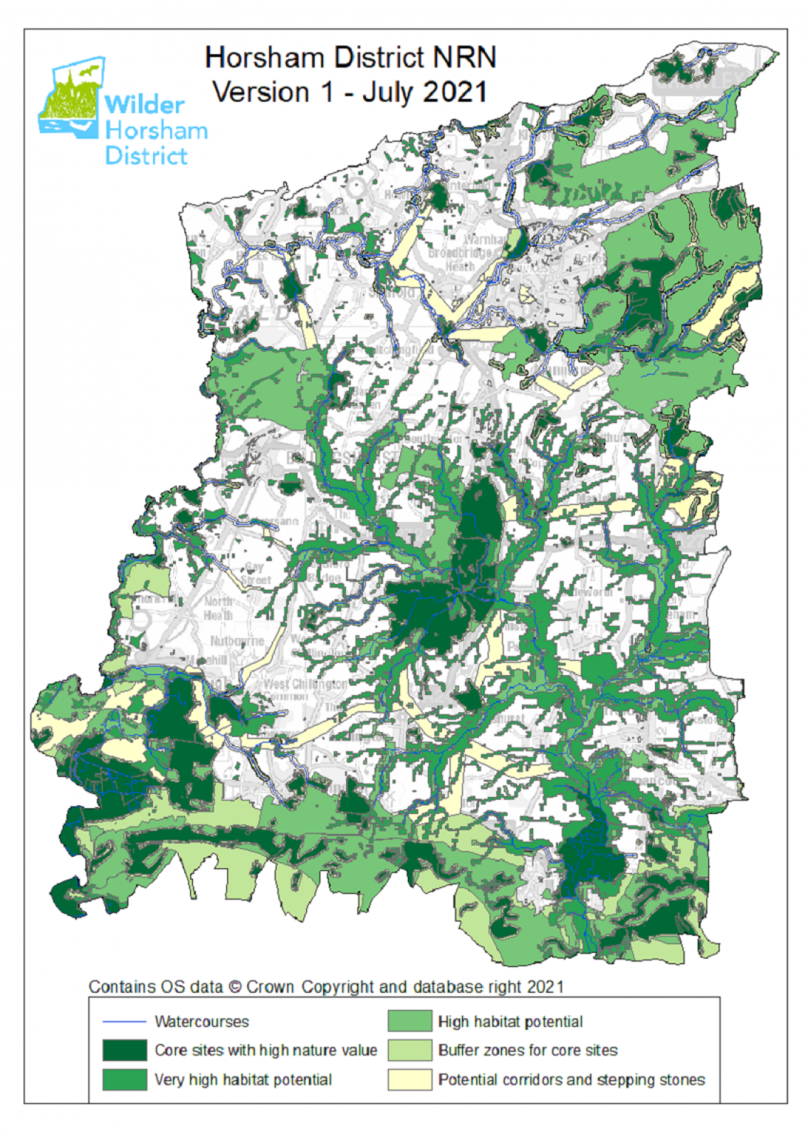
Figure 5. The first version of Nature Recovery Network for Horsham (July 2021)
References in the National Planning Policy Framework to Nature Recovery Networks
The National Planning Policy Framework contains several paragraphs relating to NRN’s and the planning system. The key paragraphs are set out below for information. It should be noted that the government periodically update the NPPF, supporting planning guidance and publish ministerial statements. The most up to date information will always be available on the Government’s website.
“Planning policies and decisions should contribute to and enhance the natural and local environment by:
(d) minimising impacts on and providing net gains for biodiversity, including by establishing coherent ecological networks that are more resilient to current and future pressures”
Paragraph 174
“Plans should: distinguish between the hierarchy of international, national and locally designated sites; allocate land with the least environmental or amenity value, where consistent with other policies in the Framework, take a strategic approach to maintaining and enhancing networks of habitats and green infrastructure; and plan for the enhancement of natural capital at a catchment or landscape scale across local authority boundaries.”
Paragraph 175
“To protect and enhance biodiversity and geodiversity, plans should:
(a) Identify, map and safeguard components of local wildlife-rich habitats and wider ecological networks, in the hierarchy of international, national and locally designated sites of importance for biodiversity, wildlife corridors and stepping stones that connect them; and areas identified by national and local partnerships for habitat management, enhancement, restoration or creation”
Paragraph 179.
The above paragraph includes the following footnote:
“Where areas that are part of the Nature Recovery Network are identified in plans, it may be appropriate to specify the types of development that may be suitable within them”.